|
Onwards toward Dreger...
January 31, 2009 - Day: 16 (4.9180S,146.4066E) -4.9180S,213.5934W
You probably checked the [ORS MAP] link on the top right to figure out that I am continuing... After receiving wave after wave of rain episodes which almost always brought westerly squalls, I was driven too far east. I could no longer maintain a southeasterly course into the Isumrud Strait south of Karkar Island. The conditions indicated that I would not clear the south end of the island; in fact it looked more like a bull's eye landing on its rocky shores.
Having already put in 18 hours of work, I laid down for a five hour sleep. When I woke up, the conditions had not improved, so I changed course toward the north end of Karkar where I would have more sea room.
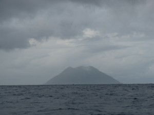
I rowed into the dark, after savoring the landscape details of Karkar's northern reaches, only 4 nm south of me. Before sunset, a few spots of wafting smoke betrayed the location of houses among the thick vegetation. At night I could see clusters of lights only along its shores. I kept rowing under the watchful eyes of Mr. Murphy. The north winds that I could have used to reach Isumrud Strait, were now blowing, pushing me toward an area marked "reef reported in 1944" -- this was the area that I wanted to clear before turning southeast.
In the dark, I was startled by a slap on the back of my head by what I first thought was a bird. Then I realized it was probably the biggest flying fish to land on my boat! Probably a good 20 cm long and 4-5 cm in diameter at the belly. Flying fish have not been as ubiquitous as before, so this was an odd surprise... I had to rinse the fish smell off my head!
By 10:30 at night, about 3 hours after sunset I cleared the northeast corner of Karkar with 0.1 nm to spare from the reef marked zone, then set the boat between the swells to receive the wind from its port side, and got back inside for another 5 hours of sleep. I had Bagabag Island in my way to the east of Karkar, which required me to wake up to verify that I was safe from the land hazard.
Today I passed on the east side of Bagabag, maintaining a southsoutheast course, which I hope to keep until I am lined up with the Vitiaz Strait on an eastsoutheast course. Then I will turn eastsoutheast to pass south of Long Island. After that the last 48 hours will be a mad rush down the strait with land alongside on my starboard side. Hopefully I will manage fine.
Erden.
|


 Another land hazard cleared today: Bagabag Island.