|
|
|
 |
| Around-n-Over |

|
 |
 |
| Question - | "What does having a dream mean to you?" |
| Answer - | "A dream is a goal glimmering in the distance; it is an inner calling which, when accomplished,
serves as the rite of passage into wisdom." Erden Eruç - Sep 17, 2004 |
| |
|
|
|
Dispatches
|
I must stop at Dreger...
February 3, 2009 - Day: 19 (5.9280S,147.6755E) -5.9280S,212.3245W
I am within 24 hours of landing this boat at Dreger Harbor. I have worked very hard over the last few days to bring this boat into position on the south side of Vitiaz Strait. Two nights ago, I slept a total of 5 hours, last night 4.
I have been on pain medication as necessary to keep the sciatica in check, which needs rest and a good supply of anti inflammatory medication. Healing is not possible for the tissue I bruised on a bad sleeping arrangement on ship en route to Lae.
A very active system of showers and storms was positioned all along the PNG shores, extending east into the South Pacific. Our friend Dane Clark writes that this large shower area is assoicated with an active TUTT (tropical upper tropospheric trough). These kept creating rain squalls keeping me from approaching land. Then I finally got my break, coming around Long Island.
I will post more once on land.
Erden.
|
Previous Dispatches
|
Onwards toward Dreger...
January 31, 2009 - Day: 16 (4.9180S,146.4066E)
You probably checked the [ORS MAP] link on the top right to figure out that I am continuing... After receiving wave after wave of rain episodes which almost always brought westerly squalls, I was dri
|
|
Quick dispatch...
January 29, 2009 - Day: 14 (3.8592S,145.1973E)
[ORS MAP] link on the top right should be working now. You can check my location there.
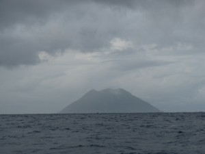
I woke up with Bam Island at 9 nm to my southwest. This is an active volcano with its perfect cone sh
|
|
Nice breeze, good sleeping...
January 27, 2009 - Day: 12 (2.3346S,144.6345E)
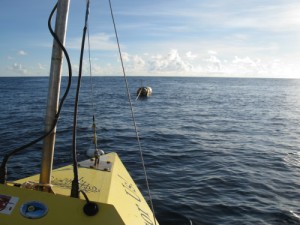
This morning I submitted two wind forecast inquiries by email, one for my location at the FAD (Fish Aggregating Device - the buoy), and one 60 nm further south at the 3rd parallel. I use an automated
|
|
|
|
|