|
Fighting for a safe landfall...
March 9, 2012 - Day 152 10.2723N,62.2358W
I hope you do remember to click on the [ORS MAP] and [MAP] links on the top right to track my progress. I got inside the Gulf of Paria on the west side of Trinidad on March the 6th.
I am now struggling to take my rowboat to Guiria in eastern Venezuela. This gulf is treacherous, it creates a lot of weather and regular rain squalls from 2 pm until 2 am. With the fierce squalls the sea gets nasty, with steep short period waves. I was dragging anchor toward a wellhead the night of the 6th, and while trying to row a few miles past it for safety on the 7th, I broke an oarlock with a broadside slammer of a wave! The winds were strong from the ENE, wind waves were building and I was rowing to beam on seas as had been the case since February the 1st (!) just to go NW. The waves were appearing like those approaching a beach, running in tight formation, ready to break but not breaking. At 20 meters depth, I did not understand this shoaling like appearance of the seas.
I had made the final decision to take my boat to Guiria in Venezuela. On the 7th, it was at 26.4 nm due 328°. The winds said I should go there and I felt that I had lost my positional advantage to exit through the Bocas Del Dragon. I had a forecast suggesting weaker and a bit more easterly winds for today through the weekend. I wanted to use those to control my approach to Guiria rather than to attempt an improbable exit through the bocas due NNE.
I have a college friend with whom I had climbed Kilimanjaro last June, İsmail Karahan, who is in Venezuela to tend to his business contracts. He became my lifeline during the o'dark hundred hours of March the 8th as I will explain. When I set anchor in afternoon on the 7th feeling at a safe distance and position with respect to the said wellhead, I never imagined the troubles that I would face overnight.
I was lulled into comfort the night of the 7th after setting the anchor. Every wave had been a splasher without exception while I set the anchor bare naked, I dove inside the cabin timing it between two waves, and dripped saltwater all over my mattress. I had a fresh towel I had not used since Namibia -- then was the time. The boat did not rock too badly; I set my alarm for 4 hours later to monitor and went to sleep. When I woke up at one o'clock, I realized the boat had drifted 3 nm due WSW. She was dragging anchor at a 1 knot average pace, heading toward shallower waters. I got out for more splashing to lower the second anchor. I had said that I would swap my 4-pronged default anchor with the danforth, and I had not. I almost paid dearly for that procrastination!
The second anchor did not grab like before. The bottom was a hard grey clay which came up pasted on the anchors and lines. Most likely anchors were not biting into this hard slick surface and simply skipping along. At the rate I was going, I would reach shallow waters in 3-4 hours and shipwreck on the downwind shore in 7-8 hours. Once in shallow waters, the waves would steepen further, making it perhaps impossible for another vessel to come to my aid. As the skipper, my priority was (a) to save my boat, (b) to reach a point from which I could continue the next phase of my human powered circumnavigation journey, and (c) break more records!
With that in mind, I called Tatiana at the Ocean Rowing Society in London waking her up at 5 am. She gracefully delivered to me the phone numbers for the respective coast guards in Trinidad and in Venezuela. I called the Venezuela number first, but there was not an English speaker. I called İsmail waking him up at one o'clock in the morning to inform him. He maintained a phone side vigil while a Spanish speaking colleague of his relayed my information to the Venezuela National Coast Guard. Just in case my anchors had crossed lines or perhaps had tangled in their own chain or lines, I pulled them and recast them carefully around 2 am under torrential rain and its squalls and splashing seas. Don't ask why I still did not put the danforth anchor at the end of the chain, that remained the wrong choice for this bottom in my system until yesterday.
While all of this was happening between 1-3 am, I also called the Trinidad CG number. There I had a lengthy talk with an officer who gathered a whole lot of details while my boat dragged along. He was probably filling a form. He confirmed that I was in Venezuelan waters, I told him of my hope that they would coordinate and pass my information to dispatch the nearest vessel.
When I got back to calling İsmail, he told me that Venezuelan National Coast Guard had not been able to raise their counterparts in Guiria and were considering sending a helicopter at night! I asked İsmail to make it clear to them that we had time, my life was not in danger, I would not leave my boat, what I needed was a tow to save my boat. No helicopter was my condition. I dreaded the consequences of a tow, but I did not want to worry about how I would continue my journey later.
By then the boat's drift was thankfully turning westerly, giving me more run before serious trouble. It later turned due 280° parallelling the shallows then by 5 am the drift stopped, perhaps I had hit softer mud after having dragged 6.5 nm WSW since sundown. I was then left with no claim for any positional advantage with respect to the winds. This anchor drag snafoo had completely derailed my hopes of working my way out of the bocas, now even reaching Guiria was in jeopardy.
The Trinidad CG operations center kept hailing me periodically on VHF Channel 16, then we would switch to 14 for an exchange of position, rate of drift and direction. As my emergency wound down, I began reconsidering. We had to call off the mayday. From 1 am until 6 am no vessel had appeared. I had not slept while monitoring my satellite phone and VHF radio. When I called İsmail at six o'clock, a Turkish colleague of his responded. İsmail had passed out at 5 am!
I left with him my decision to attempt rowing again with the easing winds and the settling seas -- they had to tell the Venezuela National Coast Guard to call off the tow request. I later called Tatiana to tell her that even if I had to take this boat to the river mouths at the NW corner of this gulf I should, then beach the boat or swim to shore if necessary. I was now glad my boat was spared and the coast guard action delayed. I had gained another chance.
I began rowing yesterday around 7:30 am and continued until the afternoon winds began to build around 1 pm. Like clockwork, I would get heavy rain and squalls at 2 pm. With all the work, my heading was due 330° or about 15° to port side of what I needed to reach Guiria. With 20 nm remaining, this would put me about 5 nm west of Guiria. As I was texting İsmail around 11 am to find out any villages or beaches with road access west of Guiria, he called me. Not having heard from me until then, they were worried and the Coast Guard vessel had launched from Guiria toward me. I pleaded with İsmail to stop them, to have the vessel recalled. There was no emergency any more, that emergency was over by 5 am! I wanted to reach land and we could hire a fisherman to tow the boat to Guiria afterwards. İsmail succeeded and the vessel did not proceed too far from port...
Despite all my rowing, when my boat began tracking NW pushed by the wind and waves, I dropped the danforth this time at the end of my 50 meter line and the chain. It was time to stop any further westing. The anchor held fast to my relief and has not budged since.
After I set anchor, the coast guard vessel PUNTA MACURO showed up around 4:15 pm. They did not speak English; I understood them as saying that Venezuela National Coast Guard instructed them that I should be taken to Guiria; they were motioning me to hop on board. I pleaded with them to let me stay, told them that all was better, butchered Spanish as in "venido de Namibia para continuar a terra" "magnana y Sabado mehor para continuar" with bunch of "por favor" thrown in for good measure. They pulled back apparently consulting their national operations center, then took off.
I hope I will not be embarrassed by having to call them back. I have just 17.8 nm left for Guiria which is at 350° from me.
I will have two options for the journey:
(a) ship the boat and press on overland through Central America to Bodega Bay, or
(b) portage the boat to Carupano or Puerto Santo north side of Venezuela, bicycle in between and relaunch toward the Yucatan and Texas without losing much time.
I am favoring the second option which would be the least complicated, least costly and probably quicker too. I will commit to one of these options after landfall. First things first, no need to put the cart ahead of the horse!
Erden.
---- oOo ----
CHARITY:
The 2011 tax year concluded at the end of December. Thank you for participating in our efforts to raise funds to build additional classrooms at the Mateves Secondary School in Arusha, Tanzania on the foothills of Mount Kilimanjaro. If you pay taxes in the United States, your contribution can be claimed as a tax-deduction. We will provide an accounting of all funds received and applied toward the Mateves cause, effective the end of 2011, sometime after my landfall.
Around-n-Over has already transferred 6,000 USD toward the Mateves cause. The team will report separately on the foundations laid, walls built... More information is available on our Projects and Score Card pages. Our Board of Directors will continue to monitor progress well into 2012.
Please remember to promote our charitable and educational projects. Your friends can contribute using the Support Us link in the left margin. If Charitable, Educational or Expedition is specified on contributions during 2012, we will allocate them according to your wishes.
.
.
|


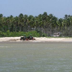 A settlement among palm trees and tractors on the beach near Icacos Point.
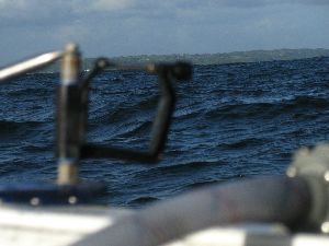
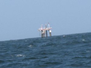 Northernmost wellhead in the Soldado SW oilfield, only about 0.6 nm away.
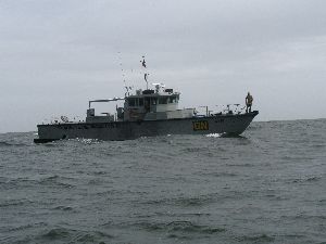 Venezuela Coast Guard vessel PUNTA MACURO approaching.